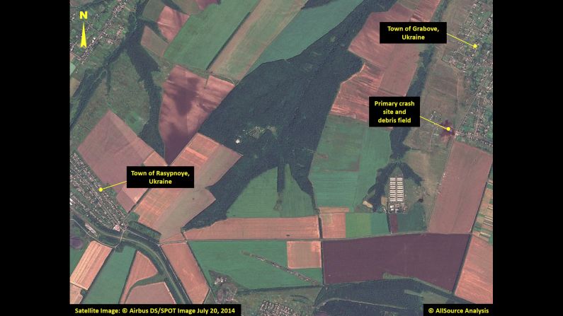
Aerial view of Malaysia Airlines Flight 17 crash site —
This satellite image shows the primary crash site of Malaysia Airlines Flight 17 between the towns of Hrabove (spelled Grabove in Russian) and Rasypnoye, Ukraine. The Boeing 777 was shot down Thursday, July 17, with a surface-to-air missile in Ukrainian territory controlled by pro-Russian rebels. All 298 people aboard died. The satellite imagery was collected on Sunday, July 20, by Airbus Defense & Space, and was analyzed by AllSource Analysis. Click through to see more of the satellite imagery:

Aerial view of Malaysia Airlines Flight 17 crash site —
Multiple locations with debris are pointed out in this image, including the site of the plane's tail section.

Aerial view of Malaysia Airlines Flight 17 crash site —
The burned fields of the primary crash site are pictured.

Aerial view of Malaysia Airlines Flight 17 crash site —
The plane's tail section appears down a road from temporary shelters and tents.

Aerial view of Malaysia Airlines Flight 17 crash site —
More debris is scattered to the left of the tail section among a field and near buildings.

Aerial view of Malaysia Airlines Flight 17 crash site —
Debris has been spotted almost two miles away from the primary crash site.

Aerial view of Malaysia Airlines Flight 17 crash site —
Refrigerated train cars are visible in this satellite image. Search teams have recovered 272 bodies, 251 of which have been loaded on trains with refrigerators, Ukrainian Prime Minister Arseniy Yatsenyuk said.