

After three consecutive years of an unusually stubborn pattern, La Ni?a has officially ended and El Ni?o is on the way, the National Oceanic and Atmospheric Administration said Thursday.
That could mean a less active Atlantic hurricane season, a more active season in the Pacific – and another spike in global temperatures, forecasters say.
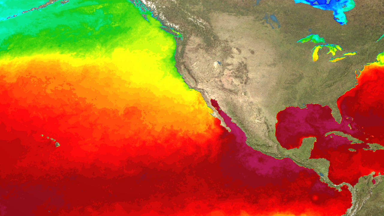
El Ni?o is associated with a band of warm ocean water that forms in the central and eastern Pacific Ocean, which has consequences for weather patterns around the globe.
NOAA’s Climate Prediction Center said “neutral conditions” are in place now and are expected to last through early summer in the Northern Hemisphere for the first time since the initial La Ni?a advisory was issued in September 2020.
The prediction center also wrote its forecast now favors “El Ni?o forming during summer 2023 and persisting through the fall.”
The transition to El Ni?o during the later summer months could have major influence over the Atlantic and Pacific hurricane seasons.
“Tropical cyclone activity in the North Atlantic is more sensitive to El Ni?o influences than in any other ocean basin,” NOAA said.
Generally, El Ni?o reduces Atlantic hurricane activity, but has the opposite result in the Pacific, where warmer waters can produce more intense hurricanes.
The warmer the Pacific Ocean is, especially in the eastern region, tropical cyclone quantity and strength can tend to increase. The Atlantic, however, sees fewer hurricanes as a result of increased upper-level winds that prevent hurricanes from developing.
El Ni?o impacts California
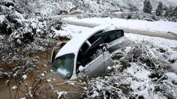
El Ni?o also significantly impacts California’s weather and could mean a continuation of the current wet pattern already plaguing the state. Traditionally, El Ni?o brings increased rain and snow across the Golden State, especially in the cool season, leading to flooding, landslides, and coastal erosion.
“Southern California is generally much more impacted with El Nino conditions bringing higher than normal precipitation,” the National Weather Service in Sacramento, California said.
But having a very robust La Ni?a winter could still have lingering effects this summer even as we transition into more of an El Ni?o pattern.
“Even though La Ni?a is coming to an end we are likely to see latent impacts for some time to come and therefore some of the … rainfall impacts of La Ni?a may still continue,” the World Meteorological Organization said.
“The lingering impacts of multi-year La Ni?a is basically due to its long duration, and continuous circulation anomaly, which are different from the single-peak La Ni?a event.”
That’s a cause for concern for many Californians, given the surplus of moisture across the state in the past two months.
Increased risk for global heat waves
The more widespread concern with the return to El Ni?o conditions for the first time since the summer of 2019 will be the warming ocean’s impact on global temperatures and heat waves.
“If we do now enter an El Ni?o phase, this is likely to fuel another spike in global temperatures,” said WMO Secretary-General Petteri Taalas.
In fact, 2022 was the warmest La Ni?a on record, and adding the additional heat of El Ni?o means the next year or two will likely climb even higher on the list of hottest years on record.

“La Ni?a’s cooling effect put a temporary brake on rising global temperatures, even though the past eight-year period was the warmest on record,” said Taalas.
El Ni?o and La Ni?a are major drivers of Earth’s climate patterns, but not the only ones.
The North Atlantic Oscillation, the Arctic Oscillation and the Indian Ocean Dipole are also have influence and are taken into account for the WMO’s global seasonal climate updates.
The change in La Ni?a and El Ni?o patterns contributes to a widespread prediction of above-normal temperatures over land areas, according to those updates.
“The El Ni?o and La Ni?a phenomenon occurs naturally,” the WMO said. “But it is taking place against a background of human-induced climate change, which is increasing global temperatures, affecting seasonal rainfall patterns, and making our weather more extreme.”